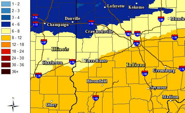
SOUTH-CENTRAL, Ind. - The National Weather Service (NWS) has announced that it has issued a Winter Storm Warning for a good portion of Indiana this weekend.
The Winter Storm Warning will be in effect from noon on Saturday until 7 p.m. on Sunday and was issued for south-central, west-central, east-central, southwest, southeast, and central Indiana. Travel will be very challenging.
In addition, the National Weather Service issued a Cold Weather Advisory from Friday at 7 p.m. until tomorrow at 10 a.m.
The impacted area includes Bartholomew, Johnson, Jackson, Jennings, Brown, Decatur, and Shelby Counties.
Heavy snow is expected, with possible accumulations ranging from 8 to 12 inches.
The heaviest snowfall is predicted for late Saturday night through early Sunday afternoon in south-central Indiana. During the period, NWS meteorologists forecast a 70% probability for 6+ inches of snow and a 60% chance of 8+ inches
In addition to the snow, south-central Indiana will face extremely cold temperatures beginning Friday. Thermometer readings will be in the teens most of the day and single digits by nightfall. At times, wind chills will be -10 and lower. The freeze continues through Monday with highs in the teens and lows near zero.
 10 East/North students selected as 2027 Lilly Scholarship finalists
 Vote early at Gather Columbus, Bartholomew Co. Office Bldg.
 Edinburgh town council approves $10.4M budget for 2027
 Edinburgh establishes official 2026 Halloween 'Trick-or-Treat' hours
 Kelly School of Business at IU, Columbus Chamber present 2027 Economic Outlook Luncheon
 Indiana Sentinels return for second season at Hamilton Center in Columbus
 Part of State Road 11 near Azalia closed Tuesday
 Bartholomew County property taxes due November 10