
COLUMBUS, Ind. - Bartholomew County Emergency Management (BCEM) and the National Weather Service (NWS) have announced that there is a slight risk for severe weather for Columbus and Bartholomew County late Thursday night into early Friday morning.
After predicted record highs on Thursday afternoon in the low 80s, a cold front will move through the area late Thursday, bringing thunderstorms and gusty winds.
Potential severe weather could affect the region from 7 p.m. on Thursday until 1 a.m. on Friday. Rain, large hail, damaging winds (70 mph), and local flooding are possible during the period. An isolated tornado can not be ruled out.
NWS and BCEM are notifying residents to stay alert and have multiple ways to receive warnings (local radio, phone alerts, NOAA Weather Radio) and be prepared to take action if severe weather develops.
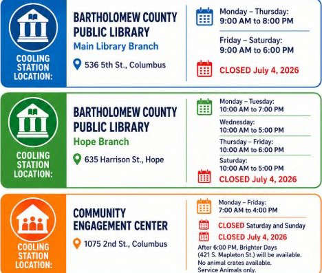 Bartholomew County opens 'Cooling Stations' to help beat the heat
 'Heat Advisory' issued for south-central Indiana
 Weeklong 'Celebrate 250' festival in Columbus starts Monday
 Columbus erects banners downtown recognizing Revolutionary War soldiers
 'Catalyst Academy' awards $40K to 8 entrepreneurs
 Registration price for Moonlight Loop bike ride increases July 1
 Columbus man gets 5 years for violation of no-contact order, other felony charges
 Flood Watch is in effect for most of south-central Indiana
